
August 2012
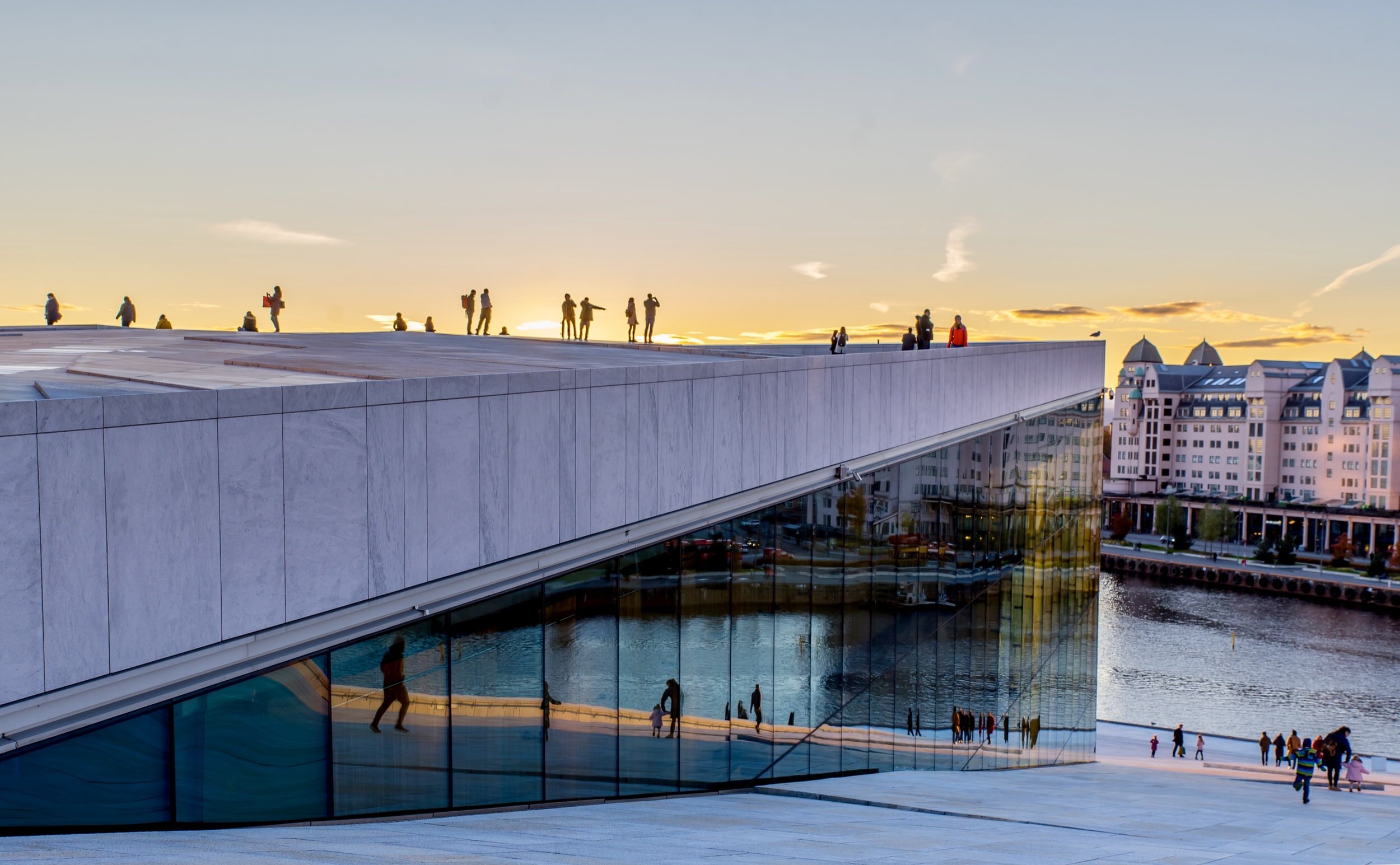
Photo: Arvid Malde
Post by Timothy Beatley
Timothy Beatley, PhD, is the Teresa Heinz Professor of Sustainable Communities & Chair of the Department of Urban & Environmental Planning at the UVa School of Architecture.
Oslo feels a bit sleepy in early July. This is partly because it is prime vacation season here. I had the chance to visit Oslo, my second trip, to further explore its biophilic qualities, to hear about recent projects and progress, and to explore partnerships with the city. In meetings with staff from climate and energy and planning, and further field visits in this beautiful city, I have become an even greater admirer of this Scandinavian gem.
Oslo’s chief planning motto in recent years has been “the blue and the green and the city in between,” which does capture nicely the basic physical context of this city. Located on the Oslo Fjord, the city is flanked to the north and east by large uninterrupted blocks for forests. Affectionately referred to as the “marka” (Norwegian for forest), they possess a value and societal importance almost mythical and certainly sacred. There is a marka line, beyond which the extension of urban development is to be prohibited, and while there have been efforts at swapping or trading land, this boundary appears largely immovable (legally but also politically). These forests comprise two-thirds of the municipality’s land area and are an incredible resource and amenity for residents.
This city’s nature works for residents because they can reach it easily and quickly, thanks to investments in public transit, particularly a fantastic metro system. Development density is low around many of the stations, boding well for accommodating future population growth around transit nodes (they’re expecting an increase of 200,000 in the city by 2030).
One day, I traveled by metro from the center of the city to the forest edge, a trip that took only 15 minutes and delivered me to the boundary of a massive forest reserve. The Sognsvann metro station is just a few meters from Lake Sognsvann, with a busy trail circling it, and, on this day, lots of families walking and picnicking along the shore. Similarly, there are other metro stations (and tram stops) that provide unusually good access for residents wishing to reach these large areas of nature.
And this ease of mobility extends even into the small islands of the fjord, with regular ferry service for the cost of a bus or metro ticket. On one recent day in early summer I witnessed these ferries filled with groups of small children, on school trips to these beautiful spaces around these islands—remote nature so close to the center of the city. It has been said on several occasions with pride that schools in Oslo (and throughout Norway) place a priority of getting their pupils outside and directly experiencing these natural resources.
There are plenty of cars and car traffic in Oslo, to be sure, but the city deserves to be given considerable credit for attempts to constrain them. Oslo was one of the very first cities to put in place a ring toll that charges cars that travel into the city. Much of the revenue generated from this ring toll goes to support public transit.
Oslo’s more recent history of planning and development has reinforced connections to the water. Perhaps, most impressively, Oslo has begun a long-term process of transforming its waterfront, putting major roadways in tunnels and creating amazing new connections with the fjord. A plan called Fjord City, lays out this vision, and much of it is happening. The city has gotten important recognition for its spectacular opera house, for example. A series of dense vertical buildings, with visually interesting designs (referred to locally as the “barcode buildings”) and spectacular views of the waterfront, stand immediately adjacent. All of the new waterfront development will be connected by a harbor promenade, which will also allow pedestrians and urban hikers to connect with the city’s more natural trails on either end. Some of this waterfront transformation has been underway for a number of years, as colleagues have reminded me that not that long ago there multi-lanes of traffic separating the city’s town hall from the water. Today it is a large plaza that links the central city—sentrum—with the fjord and provides residents and visitor the chance to connect with this amazing water environment.
That this is a marine city, it is hard to deny. And it’s not just the cruise ships and other harbor traffic that speak to this. The images of marine life and mythology seem to permeate the city and pop up in interesting ways. One day, I ended up on a street where a striking sea horse rose vertically, a beacon to the entrance of an important 1941 building (Radhusgatten 25), by notable architects Andreas Bjercke and Georg Eliassen. The most dramatic adornment was a beautiful vertical fish sculpture. And this is not an unusual sight walking around Oslo, as mermaids and fish and water scenes end up appearing on building old and new(er). The fish on the Bjerke and Eliassen building was indeed a delight and raises the question about how much biophilic value or connection to nature such shapes, images, and forms in the city deliver.
This is a city that has an ambitious planning vision and program for the future. The city is now both planning for increased density in many places in the city—especially in the northeast section, and around its metro stations—and enhancing, extending, and repairing the nature within the city. Most especially this includes the eight main rivers that flow through the city on their way to the fjord. The city’s Green Structure Plan lays out the vision of bringing all of these rivers back to the surface and restoring them to mostly natural conditions. It is a bold vision and one on which the city has already made significant progress. The Akerselva is most spectacular example to date, of a nearly complete river restoration, with waterfalls and bike and walking trails and abundant riparian nature close to dense housing. More recently the city has embarked on a major effort to similarly restore the Alna River, and has already restored impressive sections of several other of its rivers.
These rivers are also connected to and can be reached by the city’s impressive network of urban trails. These are largely natural trails conveniently marked like highways (I like the sense of parity here) by a combination of number and letter (“follow the A2,” for instance) that residents can take to many natural areas in the city. There are beautiful trail maps available to guide you into the different sections of the city.
One of the most spectacular sections of the trail—a real surprise for me—was along the A4, which I accessed from the east (connecting with the A12). This section of trail, from Husebyskogen south to the Radium-hospitalet, takes you along the Maerradalsbekken River. The sheer wildness of this stretch of river was a pleasant surprise. One wants to linger here, listening to the sound of the fast water and watching a steady stream of hikers and mountain bikers pass by (below is a small visual and aural sample of this beautiful river). There is some 365 km of these urban trails in total.
Oslo has much to teach other cities. Most important is the lesson that it is possible (indeed essential) to work on the basic elements of sustainable urban form (good transit, increasing densities around transit stations), at the same time that investments are made in restoring and growing the wilder and more natural forms of infrastructure in a city. Wild in the city is not only possible in Oslo, but a defining quality of urban life there.